Saturday 29 February 2020

Port Lincoln to Streaky Bay

We decided to round Cape Catastrophe in calm weather and keep going to the unfortunately named Seasick Bay. It was a lovely morning. The sun was shining, the sea was calm and I had fresh salmon cooking on the stove. After lunch the clouds started to gather and the barometer began to fall. We kept motoring. At dusk the clouds covered most of the sky and a thunder storm passed over us. Lightning forked down to the sea and heavy rain fell. We checked the radar and altered our course to skirt the storm. The wind increased and shifted from SSE to SSW.
Seasick Bay
The navigation bow light failed to work, so Jeremy went up on deck to replace the bulb which had blown. The BOM (Bureau of Meteorology) forecast had issued a strong wind warning for after midnight. We hoped the wind would not start blowing early.

Just before midnight, we anchored in Seasick Bay, using our chart plotter, GPS and radar to guide us in. A moderate wind was blowing. At 0100 the strong winds arrived. If we had to get out quickly, the deathly named, but safe anchorage, at Coffin Bay, was about 15 miles away.
Rocky shore, Pearson Islands
We stayed for two nights. Seasick Bay is an attractive half moon bay backed by a white sand beach and sand dunes. The reefs at both sides keep out most of the swell. Surf was breaking on the beach so we did not go ashore. We had limited phone coverage but enough to book our flights to the UK from Perth.
Rocky cliffs, Pearson Islands
Perhaps we should have waited another day as the swell was still quite big when we left on 19th February for the Pearson Islands. As we approached and saw the waves breaking on the island, we thought both anchorages would be untenable. The one in Anchorage Bay was exposed to the SSE wind. The one on the north east side of the island was protected from the SE and quite sheltered once inside the little bay. We anchored in 9m and looked at the rocky shores that surrounded us on three sides. Seals were lazing in the sun and wallabies hopped across the scrubland. Wind funnelled down from the high cliff above us from time to time.

The wind was very light but it turned toward the east and we were too close to the rocks. We re-anchored further away and put the anchor drag alarm on. We stayed the night. Jeremy woke early disconcerted that we were now on a lee shore, although there was very little wind. We weighed anchor and left in the dark at 0510.
Small settlement, Sceale Bay
We had a good sail in E to ESE winds all morning on our way to Sceale Bay, where we anchored in 1.8m. A white sand beach stretched in a gentle curve for miles, backed by sand dunes. There was no swell. We slept well.
Sceale Bay
The next day we set off for Streaky Bay. Dolphins joined us for part of the journey. Once we had rounded Cape Bauer, we started our approach to Streaky Bay, about 15 miles away. The light wind increased as we reached the anchorage and was blowing from the south at 22 knots as we anchored in seagrass off a long jetty. A sports fishing boat was anchored in the only sandy spot we could see. The anchor dragged. After the third attempt it held securely.
The anchorage, Streaky Bay
We stayed for two nights completing the usual chores of doing laundry, food shopping and filling up with diesel and water. The people were friendly and the food was reasonably priced at the hotel on the front.
 Streaky Bay Hotel
We checked the weather for our crossing of the Great Australian Bight and had a 6 day window with favourable winds and with the swell less than 3m for most of the trip. We left on Sunday 23rd February. Jeremy phoned VMR (Volunteer Marine Rescue) Esperance to let them know our plans.

Five days later, we arrived in Esperance Bay in strong NE winds, which gusted to over 40 knots as we struggled to take down our reefed mainsail.

More information on the Great Australian Bight and our stay in Esperance follows in the next blog post.

Saturday 22 February 2020

Adelaide to Port Lincoln

As we approached Troubridge Island the depth became less and less and the wind blew harder. We soon realised that the waypoint we had for the anchorage was actually on the island. We sounded our way in realising that we could not depend on our chartplotter. The sun peeped out from grey clouds showing us the shallows, but when we were ready to drop the anchor the sun disappeared. The wind took the bows away and we dragged sideways towards the shallows. A quick burst on the engine put us into deeper water as Jeremy worked the anchor windlass at top speed.
 
Late evening lighthouse, Troubridge Island
We tried again and anchored securely. All night, until the small hours, the SE wind blew. Thanks to the shoals, there was no swell – just lots of choppy wind waves. In the morning, in calm conditions, we decided to try taking a route through the shallows on a rising tide, skirting the Marion Shoals. I watched the depth sounder while Jeremy steered. We were both relieved when we found ourselves in deeper water and continued our daysail to King George Beach on the north side of Kangaroo Island. Dolphins came to swim in our bow wave and the sun shone.
King George Beach, Kangaroo Island
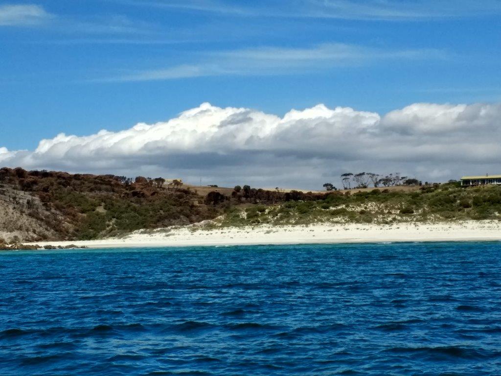
On arrival, we found the waypoint we had was off a small cove, which was next to a much larger beach. As we approached the small cove it became obvious that this would not be a safe anchorage, so we turned away and anchored off the larger beach, where there is a reef on one side and a headland on the other. It was very pretty with three houses ashore. However, we could see that fire had swept across the hillside leaving a swathe of blackness, where once there had been undergrowth and trees.

The next day was St Valentine’s Day. It was only 29 nm to our next anchorage across Investigator Strait at West Cape. We motorsailed in light winds, but as we passed the Althorpe Islands, the wind doubled in strength and put us on a lee shore to go round West Cape and into the anchorage. I was not happy as waves were breaking on the reef off the headland and the swell was quite big. We rounded the headland safely and found ourselves in a pretty anchorage with steep cliffs to shelter behind, a long, semicircular, white sand beach and a lighthouse way above us.
Sal Darago, West Cape
After lunch, we launched the dinghy and motored ashore. There was some surf breaking on the beach, which we rode perfectly and kept dry. We changed into walking shoes, found a gap in the sand dunes beyond the crumbling, sandstone cliffs and headed towards the lighthouse. We were in Innes National Park as we discovered when we found a shelter with information boards and some toilets. We enjoyed our blustery walk to the lighthouse and returned to the beach via the cliff path.
The anchorage, West Cape
Returning through the surf was a wet experience for me as a wave broke over the bows of the dinghy. There were two other boats in the anchorage, a sloop called Bellatrix and a catamaran called Even Keels. Both were skippered by single handed sailors and they were members of CYCSA and knew Steve. Like us, they were on their way to Port Lincoln. It was good to meet some fellow cruisers.
The lighthouse, West Cape
The next morning, three boats left the anchorage. The wind was fresh enough to sail with just the genoa flying. Although, we’d set off first the bigger boats overtook us mid morning, but we saw them ahead for a long time.

The swell died down as we approached the shelter of the Eyre Peninsula. We rounded Cape Donington and began our approach to Port Lincoln. We assume Bellatrix and Even Keels went into the marina. We continued to the town jetty and anchored between it and a long commercial grain store jetty.
Commercial grain jetty, Port Lincoln
We woke up on my sister’s milestone birthday. Happy birthday, Pat. All the usual chores needed to be done i.e laundry, shopping, filling up with water, buying diesel. We rewarded ourselves with lunch at Del Giorno’s. Everything is close by in Port Lincoln, but it’s a long drag up the beach with the dinghy.
Eating out at Del Giorno's, Port Lincoln
We checked the weather and a blow was coming in two days’ time. We had to decide what to do. We were going to spend the next night in Memory Cove towards the south end of the Eyre Peninsula. Perhaps it would be better to keep going and round Cape Catastrophe in calm weather, but where would we anchor and would we make it before the strong winds arrived?

We left Port Lincoln on Monday 17th February.

Monday 17 February 2020

Robe to Adelaide


Warning: there is a photograph in this blog post which could be disturbing.

Mall's Balls
We were up at 0500. The first stop was just across the marina at the fuel berth. We tied up and unloaded our empty diesel containers. Five minutes later, Jeremy returned with the empty containers and a face like thunder. For the first time in Australia the pay at the pump machine rejected his credit cards. We had enough diesel in the tank for our 185nm overnight passage to Adelaide, so we left, annoyed that we could have spent an extra half hour in bed.
Adelaide Arcade
We avoided several crayfish pots in the bay and motorsailed with the wind and a 2-3m swell behind us. In the afternoon, we were able to sail with the genoa only flying as the wind strengthened. The sea became confused as darkness fell and quite boisterous with breaking waves on top. We had a full moon to light the way.
Pigs on the loose
The wind died down after midnight and the engine was switched on until early morning, when the wind strengthened again and went behind us. Jeremy poled out the genoa. This combination of sailing and motorsailing continued for the rest of our journey. We had checked the tides for the Backstairs Passage, which is an 8 mile wide gap between mainland Australia and Kangaroo Island. Other cruisers had reported 3 or 4 knots against them in this passage. We had the tide with us and were glad we’d kept our speed up to go through with the tide.
Town Hall
The sun shone the next day but the tide eventually went against us and the wind calmed down. On went our trusty motor and the genoa was furled, as we spotted Adelaide in the haze ahead. Jeremy had spoken to Sarah at the Cruising Yacht Club of South Australia (CYCSA) on the phone and booked a berth in their marina for four nights. First, we went to the fuel berth in North Haven Marina and filled up our tank and empty cans. Then, we motored round to our berth in the east marina and found a work boat was in it. Fortunately, a nearby berth was available and we tied up. It was 1800 on Saturday 8th February.
Regina Imperatrix
Avid readers of our blog will recall that we met Steve and Caroline Harrington and Caroline’s sister, Danielle, in Vanuatu back in July 2019. Steve had been very helpful to us when we spent a couple of hours aboard his yacht, Golden Cowrie. He’d recommended CYCSA marina for our visit to Adelaide and here we were! We contacted Steve and met up with him for lunch at the club bistro the next day. He continued to be helpful putting us in touch with Rod and Alan, who later gave Jeremy local information on anchorages from Adelaide to Streaky Bay. Steve also sent us a link to https://blog.arribasail.com/p/sailing-south-australia.html . This blog lists anchorages in South Australia with information on shelter and holding. Although the waypoints did not always agree with our chartplotter, we exercised caution (as advised) and anchored safely. Another useful resource is Zulu Waterways, but a phone signal is needed to use it. We downloaded a cruising guide to South Australia from www.JACKandJUDE.com for 10AUD (£5 approx.)
In the Botanical Gardens
CYCSA has secure berths, hot showers, cooking gas, a barbecue area, a restaurant and many friendly members. There is no laundry and no laundrette within walking distance. Just a short walk away there’s a supermarket, butcher's shop, post office and hair salon. Next to the shopping centre is the railway station with trains to Adelaide every half hour.
Beautiful lily
We spent two days exploring Adelaide. We booked an historical walking tour with Kat; spent an afternoon in the Museum of South Australia; rode the free circular city bus; walked in the Botanical Gardens and explored the Art Gallery.
Art Gallery sculpture which looks fabulous at night (apparently)
We left CYCSA on Wednesday 12th February at 0600. The next few days would be spent day sailing. Our first anchorage was 38nm across Spencer’s Gulf to Troubridge Island.
Misogynist Sculpture?
 

Tuesday 11 February 2020

Portland to Robe

We spent a pleasant final evening in Portland. There were three visiting boats on our part of the marina: Sal Darago, Butcher’s Bird and Cavatina. All the crews went on board Cavatina for sundowners. Butcher’s Bird and Cavatina had recently crossed the Great Australian Bight going east, so we were able to discuss anchorages while we socialised.
Kathy at breezy Portland Bay
When we woke up the next morning, both of our neighbours had gone, one towards New South Wales and the other to Tasmania. The wind was good for us to leave, but there was a 4 metre swell, so we waited until the afternoon. During the morning we filled all our water tanks and containers and prepared a three day chicken stew.

We left our berth just after 1400 on 4th February. At first we had to motorsail close hauled until we rounded Cape Nelson. The engine was switched off at 1600 and apart from a 45 minute motor while Jeremy took down the mainsail and poled out the genoa, we sailed all the way to the approach to Robe – 140nm. Dolphins came to ride our bow wave.
Jeremy at the old Customs House, Robe
On the way it was Jeremy’s birthday. Happy Birthday. You’re how old?! It was cold, particularly at night. I wore my Damart triple force thermals underneath all the usual sailing attire. As the day progressed the wind strengthened. Our wind instrument went berserk and started giving us wind speeds from 10knots to 65knots. It was probably blowing 20-30knots from the SE and we were zipping along with just the poled out genoa. Later, I persuaded Jeremy to reef down.

As we approached Robe, we had to be careful to avoid shoal patches and reefs. Jeremy phoned the Harbourmaster and booked a berth in the marina. He was told about the entrance buoys and advised to keep 1 metre from the red buoy on our approach. It was a bit scary watching the depth sounder record only 0.6m below our keels, but we were soon through the short channel and into deeper water in the marina. Once we were secured the Harbourmaster came by and gave us a gate key, a map of Robe and a form to fill in for the marina office. The first night cost 48AUD and the second night cost 25AUD, approx. £26 and £14. We stayed two nights.
The bay at Robe
Before we went ashore to enjoy the delights of Robe, we planned our course for our next passage to Adelaide. The wind was continuing south easterly and looked like it would be best to leave on Friday. We checked the tides for an 8 mile wide gap called the Backstairs Passage, where the tide can run at 3-4 knots.
Robe Marina
Once ashore, we paid our marina fees, went to Tourist Information and decided to have a go at the self guided historical walk. We had a map and written information so what could go wrong? Unfortunately, the map had many blue dots on it but no numbers to go with the written information. Fortunately, all the buildings had blue plaques on them, so eventually, we found most of them.
Can you spot Sal Darago?
We celebrated Jeremy’s birthday a day late with a steak lunch in the historical Caledonian Hotel washed down with a local beer. In the afternoon we continued our walking tour and provisioned at the supermarket.
Jeremy and Kathy at Robe
Robe has a lovely, relaxed, holiday atmosphere and a vast, sandy beach. It’s definitely worth a visit, but if you intend to arrive by yacht, check your draft.